Brief History of Angmering
The village of Angmering is located approx.
2 miles north of the English Channel (La Manche) in the county of West Sussex.
It is situated roughly halfway between the towns of Worthing and Littlehampton
which are both about 4 miles to the east and west respectively. The parish is
about six miles long (from north to south) and two miles wide and covers some
1900 hectares.
Although its population has shown continual expansion, particularly since the 1930's, with many new developments, Angmering has retained its rural charm principally due to the preservation of its village square (see photo right) and the designated Conservation Area which contains many ancient and attractive buildings of brick and flint, some timber-framed. The oldest of these dates back to the 14th Century but a number of fine 16th to 18th Century houses and cottages still exist today.
One of the earliest settlements within the present parish boundary was Roman or Romano-British. The remains of a substantial and luxurious villa, dated between AD 65 - 75, lie beneath farmland about one mile to the west of the village centre. The bath house alone was comprised of eight rooms. An Iron Age ditch was discovered close to the villa.
However, during the Summer of 2001, a Middle Bronze Age (c.1500 BC) settlement was located approx 700 metres north from the centre of the village. Additionally, a second site approx 700 metres to the north-east of the village centre revealed settlements from the Mid- to-Late Bronze Age, Iron Age (c.750 BC to 0 BC), and Saxon (c.450 AD to 800 AD).
The name "Angmering" probably derives from a Saxon farming settlement of about 600AD. It is thought that the original name was "Angenmaering" meaning Angenmaer's people. Various name changes took place over the centuries and these included Angemeringatun, Angmerengatum, Angemaeringum, Angemeringe, Aingmarying, Angmarrying, Angemare and Ameringe. Towards the end of the 9th century Alfred the Great, King of Wessex, bequeathed to his kinsman Osferthe ‘... Angmerengatum and the land that thereto longyth’.
Prior to the Norman invasion in 1066, it would appear that there were two manors which were recorded in the Domesday Survey as being in Angemare; they were probably the manors of East and West Angmering. Following William of Normandy's ousting of Harold Godwin from the English throne, the manors appear to have been subdivided into five, these being East and West Angmering, Bargeham (later Barpham), Ecclesden and Ham. None of the original buildings exists today. The current Ecclesden manor house derives from the 17th Century and the present Ham Manor is of Georgian origin. One wing of West Angmering's 16th Century manor house, New Place, remains although even that was a replacement for the original manor. The other wings of this substantial house were demolished in 1784 and some of the material used to reconstruct the magnificent Shelley mansion at Michelgrove.
Angmering was a relatively prosperous village in the 14th and 15th centuries primarily due to the quality of the soil, it being considered some of the best agricultural land in the region. Sheep farming was also one of the principal industries. This may have drawn Portuguese wool merchants to the area, three of whom lived in Angmering during this period. In 1384 it was classed as a town and in that year received a charter to hold a Saturday market and an annual fair.
 Today's parish of
Angmering originally comprised three separate parishes, namely, West Angmering
(St Margaret's), East Angmering (St Nicholas) and
Bargeham (nearly three miles to the
north). All these churches had 12th Century origins. The two Angmering churches
were unbelievably close being only 100 metres apart and located near the
village centre. Following the Reformation, Bargeham and East Angmering churches
were demolished or left to fall into ruin and the three parishes amalgamated
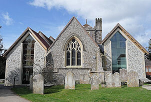
into one (i.e. St Margaret's) in approx. 1573. The present church (see photo
left) largely dates from the mid-19th Century, but its tower (constructed
in 1507) was retained.
Today's parish of
Angmering originally comprised three separate parishes, namely, West Angmering
(St Margaret's), East Angmering (St Nicholas) and
Bargeham (nearly three miles to the
north). All these churches had 12th Century origins. The two Angmering churches
were unbelievably close being only 100 metres apart and located near the
village centre. Following the Reformation, Bargeham and East Angmering churches
were demolished or left to fall into ruin and the three parishes amalgamated
into one (i.e. St Margaret's) in approx. 1573. The present church (see photo
left) largely dates from the mid-19th Century, but its tower (constructed
in 1507) was retained.
The period following the Reformation also brought other changes. Land formerly belonging to the Church was sold off to the new landowners to solve Henry VIII's economic problems. Sir John Palmer, described locally as a man corrupt in conscience and minded much to avarice, bought land previously held by the Abbess of Fécamp, enclosed land in West Angmering, and immediately drove off the copyhold tenants, destroyed their cottages and orchards and exploited the richness of the agricultural land. The tenants complained to the Star Chamber but their appeal was unsuccessful. As a result of their failed action, he vindictively warned them "Do ye not know that the King's grace hath put down all houses of monks, friars, and nuns, and therefore, now is the time come when we gentlemen will pull down the houses of such poor knaves as ye be".
Angmering grew slowly during the 17th to 19th Centuries and principally supported the local agricultural community. Further land enclosures by the gentry and principal farmers at the beginning of the 19th Century consolidated land holdings for this section of the community producing more economic parcels of land but, for the less privileged members of the community, access to some of the commons and other land was lost and their fortunes diminished, many into poverty. Some saw emigration to Canada or Australia as a way of improving their lives. By about 1840, Angmering's annual district hiring fair had gone and, what was once a small town with a former market, had declined in status to a village.
The Agricultural Revolution, combined with emerging technology on several fronts, had its own impact on Angmering bringing a railway to its southern boundary in 1846 allowing greater movement of the population and easier export of produce. This produce was largely the result of a market gardening industry which developed to serve the emerging local seaside resorts and the needs for such produce in cities such as London and Birmingham. The new railway was a vital link in getting fresh produce to these cities. Improving health and survival rates saw a burgeoning population and a demand for more housing. Communications also improved through the new postal service introduced in the 1840's. The 1881 Census indicates increasing types of employment in the village, many probably unknown a generation before - plumber, chemist, threshing machine engine driver, station master, postmaster, greengrocer, stationer, a county policeman, and even retired annuitants from the City of London.
Unfortunately, the sweeping modernisation of Britain in the 1920's and 1930's also impinged irreparably on Angmering and many ancient houses and cottages within the village were demolished in the name of "progress", a situation which we hope would not occur today with greater appreciation of our heritage.
The population of the parish grew from 708 to 1232 between 1801 and 1931, a relatively modest growth. After WW2, the population expanded at a far greater rate and then between 1961 and 1971 rose from 2850 to 4816. The population in 2001 was 5812 but expanded to about 8000 people with the building of the Bramley Green Development between 2002 and 2010. In May 2014, Arun District Council approved, in principle and without any enhancements in the infrastructure, the construction of 600 houses on land to the east of Roundstone Lane, work commencing on the first site (Swanbourne Park) at the end of that year. By 2025, or perhaps before, it is estimated that the population of Angmering will have risen to 10,000.
In 1976, Angmering was twinned with the French town of Ouistreham-Riva-Bella in Normandy.
Some Angmering History Facts (PDF)