The Square and The Green
by RW Standing
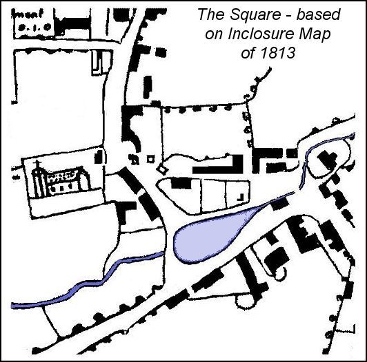
Village Greens are the focus of many ancient communities in England, often areas of common grazed by cottagers cattle and sheep. Such may be thought the origin of Angmering Square, still the village centre with its shops on two sides, village hall, war memorial, and parish church nearby. But was it always the village green?
There are still those who know that a branch of the Black Ditch once flowed down Water Lane and across the square, before it was culverted in the 19th century. Where the green is today a pond waxed and waned with the seasons, and at times needed a ferry to cross it, which can be believed with a quarter acre of floodwater.
But
if we imagine the square in a state of nature, without its houses and shops, we
are left with a triangular depression of two acres between sharply rising
ground to the north, where East Angmering church stood, and the south-east with
its fifteen feet high bluffs rising to a former croft called the Old Garden.
West Angmering church, with part of the vicar's glebe, also overlooked the
stream from the northwest, close to where it discharged towards Black Ditch,
where the medical centre has recently been built.
Perhaps even as late as when the churches were being built, Ecclesden Brook would, at times of spate, rush down to inundate this whole two acres as a lake, before cascading westwards and on towards Poling and the floodplain of the river Arun. No doubt, in normal seasons, it was a convenient watering place for the village. The whole area belonging to the lord of the manor as waste, and road.
However that may be the ancient Saxon lanes formed a carfax, rather than crossroads, around what was called the “Great Pond in Angmering Street” in local deeds. When flooding took place, Bakers Row lane [Church Road] formed a convenient detour. In any case the old village was strung along the High Street, with another centre at Ecclesden before it was deserted, and Cow Lane provided a perfectly good route south from the east end of the Street.
By some quirk of history a large swathe from just south of West Angmering churchyard gate, south to where the village hall has been built, was part of Poling parish, a parish outlier, although it and the rest of the square belonged to East Angmering manor. The undercliff outskirts gradually being sold and leased out for cottages and farmsteads, as rural forerunners of present day shops and terraced houses.
In the Poling outlier, the highest land lay to the north, and here two cottages were eventually built. In 1679 these were paying small copyhold and leasehold rents.
Richard Lidbitter, his wife Elizabeth and son John, held the copyhold cottage next to the churchyard entrance, with half acre of land, at 3s 4d rent. Described as a house, with the highway north and east, West Angmering churchyard west, and Joan Chambers garden to the south. Joan Chambers holding her house by long lease dating from 1614, and virtually a freehold, at 4s rent. The Vicarage land of West Angmering called Hempshires west, and Richard Lidbitter's backside north - the backyard of his house we would rather say. The foundations of Lidbitter's cottage are now beneath the church car park, and Chambers' house is where shops have been built.
On the other side of Arundel Road another strip of waste, directly below East Angmering church, became what is now Church Road and its houses, but which for the most part of recent history was Baker's Row. This appears to have been divided at an early date, between a copyhold house at the west end and a freehold house at the east end, which may be identified as Conyers.
The house at the west end, with its lands, has an involved description in 1679, but in essence Thomas and Richard Charles held it copyhold, at 20s rent, but this included the three acres Conyers croft on the north side of Water Lane. The site was quite clearly defined - The house and Garden bounded by East Angmering Church yard on the North, by the close of Hugh Penfold on the East and by the Highway there on the South and West.
The house that is now called Conyers, at the other end of Bakers Row, is also described fairly convincingly. Hugh Penfold holding it as a freehold, at 2s 8d quit rent. The Messuage [house] and backside by East Angmering Church yard on the North, by Angmering Street on the East and South, And by the Lands of Thomas Charles on the West. Attached to it was a garden, south of Church Road, adjoining Blaber Cottage.
Beyond Conyers at the junction with Water Lane there were two more houses. The first on a site associated with the present Lamb Inn. Here Elizabeth Sturt held a small plot of land with a house on a long lease, with lands belonging to Thomas Charles on the north and lands of Thomas Carter on the east. Although not named as such, the land to the north may be taken to have been Conyers croft. Next to it Thomas Carter can therefore be deduced as having his dwelling, described as a copyhold cottage, with the same land to the north and Elizabeth Sturt west. Angmering Street on their south side. This may well have been the site of Angmering House, well known in later years for its eccentric crenellated parapet.
As mentioned the only other house nearby at that time wasBlaber Cottage, as it is known today by very good reason that the Survey names that family as owners. John Blaber and wife Sara tenants of this copyhold cottage, at 6s 8d rent, with the garden of Hugh Penfold to their east, and Angmering Street, that is the Square and Arundel Road bounding their other sides.
On the other side of the Square, at that time largely stream and pond, the third and final area of waste would also gradually be occupied by cottages and farmsteads.The Red Lion inn, at the west end of The Street was not in the Square, but south from it was a large farmstead known latterly as the Rosery, demolished within living memory.It is unfortunate that this survey did not provide more detailed descriptions of houses, all we are told is that there was a freehold messuage, barn, and forty acres of land called Mill Field, at an unstated quit rent. The highway to its north and west, with Cottrills croft and the common field to its east. No doubt the cattle on this farm made full use of the pond, whilst adding their flavour to the rutted highway
Of particular interest is that it was owned by Thomas Palmer Esq. A descendant of the very Palmer family that had earlier owned the whole of Angmering, before selling it to Thomas Bishopp of Parham. In very few more years, before 1770, the last member of this family in Angmering had died.
Surprisingly, no other houses existed in that undercliff area. There is a possibility that some other freehold cottage was there of no concern to the survey, but other sources provide a clue that none did exist. Another of those rare early deeds survives, dating from the year 1734, when Thomas Henty husbandman of Angmerin, acquired a 99 year lease toa 'parcel of waste ground' bordering on the highway from Angmering Street to Preston, and next to a plot called Old Garden, belonging to John Edmunds the owner of the Rosery at that time. The exact cottage built on this site is not known, that and other cottages on this site have been demolished.
But it is probable that the whole of the remaining waste, south of the farmstead, was leased or sold at this time. The northern section being occupied by a house called Elmgrove, which may still be seen today, having the date 1734 over its door. Ann's Cottage, next to it, is also believed to be of that period although documentary evidence for this is lacking at present.
At the beginning of the Eighteenth century, the only buildings known to have been in existence in the Square, were the two cottages on land adjoining the churchyard, where are now shops. Nearby in Church Road, what is now known as Blaber Cottage, with St Margaret's opposite and Conyers at the east end of this short lane. Beyond that and edging into Water Lane, two more houses about which little is known, partly where the Lamb Inn is today. Eachways and the Red Lion inn, were more part of the Street scene than the Square. That left only the Rosery and its extensive farm buildings on the south east side of the Square. If one or two humble cottages were associated with the Rosery, they have been lost to history. Ann's Cottage, Elmgrove, and another cottage south from that arrived by 1734.
Any medieval and later archaeology that existed, is now either obliterated by modern buildings or locked away under them. The only archaeology surviving above ground is contained in Conyers, St Margaret's perhaps, and Blaber Cottage. Demolition of the Rosery after the 1939-45 war, was one of those all too common acts of vandalism in the name of progress and commerce, as if Angmering did not have tracts of open land on which to build all the shops and facilities it needed.
The
Village Green was originally a pond and it is probably no coincidence that this
was drained and the stream culverted, early in the 19th century, about the time
that RW Walker of Michelgrove began his coach service through the village,
between about 1813 and 1825. His coach road at Long Furlong continued through
Angmering as an extension of Water Lane, and then past Ham forming what became
known as the Rustington bypass. It was taken over as a public turnpike route in
1823, and survived as such until 1878.
Harris, in one of his 1910 pamphlets has an interesting note about this event.
About this time the Barrel Arch was built by C. Bougard, bricklayer, and the
large pond in the square filled up. This vault was clearly the new culvert. A
blacksmith's shop, standing on the site of the present finger post, was also
removed to the west. There was indeed a smithy in the road, at the north end of
the present green, shown on a map of 1814. In 1795 William Hills, tenant of
Blaber Cottage, also paid rent for a smithy, and it may be assumed it was that
very building, a new smithy being built by the cottage to replace it.
Development
of the village green periphery got under way in the 19th century. Henry Baker
acquired ownership of the Church Road properties in 1789, known as Baker's Row
or Pook's Hill, but excluding Blaber Cottage. It was probably about 1800 or so
that he built the present row of four cottages on the east side of St
Margaret's. His family continued in ownership until 1911, at which date Mrs
Mant undertook considerable alteration and construction work to convert Conyers
into the present three houses, Conyers, St Nicholas, and Little
Avenings.
Blaber Cottage appears to have been Blaber property long before the year 1645
given by its datestone, and the initials WO clearly do not match the name
Blaber. In 1775 this copyhold was made a long lease with William Hills in
occupation. It ceased to be a blacksmith dwelling late in the 19th century,
when ownership was taken over by William Langley, and at least briefly used as
two dwellings. It was he who built Blaber House, at the south end of the croft,
by 1880, opening his grocery shop there. Some part of the smithy structure is
believed to survive in this house.
From
land tax records, in the absence of anything more definitive, it is evident
that 'New' Lamb Inn was built shortly before 1780, by John Penfold a
victualler. It is unclear whether this meant a new inn, or a new Lamb to
replace a previous establishment of that name. His old house continued in
existence for a while but where this was is not yet known, possibly the nearby
Elizabeth Sturt dwelling of 1679. The Lamb has all the appearance of its date,
rather than an older house refashioned. Later deeds indicate that the Lamb site
was leasehold from the manor for 900 years, but the date of origin is not
given. It may be suspected that it occupied roadside waste, similar to other
sites around the Green. The inn passed through various hands until in 1839 it
was acquired by Osborn & Co, with Thomas Wilkinson the best known landlord
in 1850 and throughout the Victorian period.
There
is a problem with the house which stood next to the Lamb Inn, with its Gothic
style windows and crenellated parapet, once known as Angmering Cottage. Strip
away the outrageous facade and what stood behind may have predated the 19th
century. At the moment it is impossible to tie this house in with the 1679
copyhold belonging to Thomas Carter. At the end of the 19th century its well
known occupant was James Terry the butcher, two of whose sons are named on the
nearby war memorial. This site is today car park next to the inn.
Across
the pond, or what is now the Green, the Rosery farmstead had been purchased by
John Edmunds from John Palmer. It seems fairly evident that it originally
included a strip of land through to the Street, and at some time before 1743 a
small plot was acquired by Hugh Foster for a house that became the Red Lion
Inn.
Waste
south of the Rosery, occupied by the three new houses, would be the first area
to be entirely developed during the 19th century. Elm Cottage had been known as
Sturt's, presumably from the name of the person who built it, hence the
datestone initials. Soon after Henry Woolvin purchased this house, in 1863, its
south garden was utilised for the construction of three smaller cottages, which
after the 1939-45 war were converted to one dwelling as Dolphins Cottage. There
was a workshop attached to Elm Cottage before the houses are said to have been
constructed and some part might have been contained in the new cottages. In the
mean time the 18th century cottage to the south, owned by William Best and
later William Jarrett, had its surrounding garden developed as Elmgrove
Cottages, some five or so in number. These last have been replaced by a modern
terrace of houses.
Ann's
Cottage, named rather belatedly from the last of the Ragless family to live
there, passed out if their hands in 1923. Henry Ragless had been the Older's
School master for twenty years from 1826, and evidently acquired the house long
before he retired. Its roof was originally thatched, as was Elm Cottage,
otherwise neither cottage has changed much in external appearance.
Little
can be said about the Rosery, other than the fact that it stood behind the
present shops, and was a rather barn like half-hipped thatched building, facing
across the Green. In this it was reminiscent of many late medieval houses.
Anecdotal sources speak only of Tudor fireplaces and adzed timbers. After 1840
it ceased to be a farmhouse, and soon afterwards a large wing at its north end,
eventually extended towards the road, and known as London House, became the
dominant feature. A succession of grocers had this as one of the principal
shops in Angmering.
With
the yards and farm buildings no longer required, various other houses were
constructed on this "brown field" site. This included a terrace of four
cottages, shortly before 1861, today converted to the two Byfleet houses. North
of London House another small cottage by the road, existed transiently,
replaced by a hipped roof building in the early 20th century, which was
recently the Record Shop.
Of
more interest, the long brick faced flint building, just south of what was the
Red Lion, was not in fact in the 19th century Rosery farmstead but on a remnant
of land left over when the Lion was built. John Smith in his will of 1854, gave
this recently built house to his daughter Jane, the wife of Zebedee Peskett.
Zebedee and sons were of considerable significance to Angmering and locality.
He was the owner of a blacksmith forge, in the yard behind, and had a hardware
shop in the house, which many may recall in more recent years. At least one son
was a builder and developer, with Kingston Gorse one of his prime enterprises
after the Great War.
Across
the pond again to that strange Poling parish outlier adjoining the churchyard.
That part south of the stream, where the village hall of 1926 is, was no doubt
more prone to flooding than the north section where both the ancient cottages
stood. Being in another parish their history is difficult to trace, which is
why few people will realise how much of a hub of village activity this was in
the 19th century. Hub indeed, with a wheelwrights shop there, and the north
cottage a blacksmith business in direct competition with Blaber Cottage.
Later
in the century these cottages, or rather their successors so far as they were
rebuilt, as appears from photographs, were owned by Richard Winchester the High
Street shopkeeper. Walter Cheeseman lived there prior to taking over the Blaber
House shop from William Langley.
If Squire Gratwicke of Ham Manor had got his way the story would have been very different. In 1853 he purchased a former cottage, used as a candle manufactory, from the Baker family of Conyers. This was rebuilt as the Sexton's Cottage and Vestry, forming part of his grandiose scheme for the church, reconstructed in the style that was all the rage at that time, Early English Gothic. At the same time, there had clearly been an idea of including the 'Poling' cottages in this scheme. An architects illustration shows the whole complex of buildings, church, school, and cottages, all rebuilt in the that style. Other buildings in the Church Road area were conveniently removed from view in this artistic perspective, presumably by the architect Teulon.
RW Standing
Revised
and extended - May 2006