Background
The concept of allotments is not new; in fact, it stretches back over 1000 years. However, it was not until the mid-19th century that we see the commencement of allotments as we know them today. Initially, the General Enclosure Act of 1845 required the local authorities to make provision for the landless poor in the form of "field gardens" limited to a quarter of an acre. By the end of that century, they were commonly known as "allotment gardens".
However, the 1845 Act proved to be ineffective and it required the Allotments and Cottage Gardens Compensation for Crops Act 1887 to drive local authorities to provide allotments 'if there was a demand for them'. But it was the establishment of parish councils in 1894 that gave some teeth to the 1887 Act and saw the establishment of allotments expand across England.
The Smallholding and Allotment Act 1907 imposed responsibilities on parish, urban district, and borough councils to provide allotments, and further legislation in 1908 consolidated previous acts and resolved various anomalies.
In the UK, allotments are small parcels of land rented to individuals usually for the purpose of growing food crops but not exclusively for cultivation. There is no set standard size but the most common plot size was 10 rods in the late-19thC and early-20thC, an ancient measurement equivalent to 302 square yards or 253 square metres. However, 15-rod allotments and 5-rod allotments were not uncommon. As land availability decreased, a standard or "full" plot was often reduced to 5 rods.
In Angmering, two allotment gardens were established by 1897. These were the Steyne/Stein allotments, situated to the east of Water Lane, and unnamed allotments situated north-west of St Wilfrid's RC School, Arundel Road. By the end of WW1, further allotments were established at the end of Honey Lane (off the High Street).
The Steyne/Stein Allotments
These first appeared on the 1897 Ordnance Survey map shown as "garden allotments" on land owned by the Somerset family, owners of large tracts of land in Angmering and nearby. They were the Lords of the Manors of East and West Angmering. In 1840, the Somerset's ancestors (the Bishopps and the Pechells) owned 989 acres of land in Angmering and more than 100 acres in Patching and Goring. Until quite recent years, their seat was Castle Goring on the outskirts of Worthing (A27).
In 1896, Angmering Parish Council reached agreement with the Somerset family to lease 1½ acres of the meadow (marked 362 on the 1897 OS map) on the south-east side of Water Lane. This stretched up to what is now Hillside Crescent. A gravel pit was situated within that plot, to the east where Hillside Crescent is located today, which the Somersets had access and Right of Way. In 1907, a further Agreement set the yearly rent at £5.
The very first renters of those allotments were James Terry, Thomas Hammond, Albert Hammond, Alfred Woolgar, Thomas Green, James Parsons, William Edmunds, David George Parsons, George Green, Charles Pelham, Joseph Winton, Alfred Smith, Henry John Langrish, Henry Green, Daniel Stringer, and George Thomas Smith.
Fifteen of those original tenants took on 10 rods each and signed individual agreements with Angmering Parish Council, with the Rev James B Orme, as chairman, signing on behalf of the Council. The cost was 5s 10d a year. James Terry rented 15 rods at 8s 9d, and George Thomas Smith, 15 rods at 8s 2d. The cost of 10 rods (i.e. 5s 10d) is the equivalent of approx. £44 today. It appears that most plots were used for growing vegetables, but there were instances where chickens were kept.
Having lost his seat on Angmering Parish Council in 1907, the builder and Socialist benefactor, Edwin Harris, was scathing of the Council and the land given over to the allotments. In his 1910 political and history pamphlet he wrote:
"The Parish Council also provide Allotments if requested. Our Council have provided about one acre for this purpose, and it is, without doubt, almost the worst acre in the parish. It has a violent slope to the north, it is bordered with trees, and it is filled with roots and stones. The rent is £4 per acre, or more than tree times the price recommended by law.
In 1912, the Somersets agreed to lease an additional ¾ acre of pasture to the Parish Council alongside the original area at a cost of £7 10s 0d a year (about £1072 today). In the 1920s, housing was built on the gravel pit site on the eastern side of Hillside Crescent and the area there was colloquially known for some years as 'The Pit'.
The last reference to the allotments there was on the 1962 OS map. After that, the Somersets sold the land to developers, and the Cumberland Road/Crescent estate was built.
Incidentally, the allotments' name - the Steyne - means stoney place, which appears to affirm Edwin Harris's criticism of the land. The old river banks or the ancient raised beach appear responsible for the accumulated small stones and also formed the gravel pit on the site.
The Norfolk Allotments
I am unaware of a name given to these allotments, but they were situated on land to the north of the St Wilfrid's RC cemetery.
Unlike the Steyne allotments, they are not well documented, and there does not appear to be any reference to them in the West Sussex Record Office (WSRO) catalogue. Like the Steyne allotments, the first reference to them is in the 1897 OS map, again as "garden allotments".
Having no record of them at WSRO, the obvious place to search was the 1836-40 Tithe Commutation map and schedules. It was here that the owner of the site was established as the Duke of Norfolk. At the southern end of the allotments was the St Wilfrid's RC School and the attached former St Wilfrid's RC Church.
Unlike the Somersets, the Duke of Norfolk did not hold much land in or close to Angmering village centre. However, he did own virtually all the land to the west of Arundel Road up to the A27 including the Old Place and New Place farms. His total holding in Angmering (excluding Barpham) was nearly 700 acres.
There is no record of the rents paid for the allotment plots or to whom but probably to an agent of the Duke or maybe the priests at St Wilfrid's. Recent anecdotes suggest that plot sizes may not have followed the national pattern. Some plots were extremely large enabling one plot tenant - William Cooper - in the mid-20th century, not only grew vegetables, but also keep pigs, cows, and chickens.
In 1963, a strip of allotment land at the southern end was given to St Wilfrid's which was used for doubling the size of the Roman Catholic cemetery. The twitten leading to the cemetery was also widened, possibly a few years earlier, and a new entrance created. By the mid-1960s, the Duke had sold the allotments for housing. Building commenced with the bungalows at the beginning of Bewley Road, but allotments continued to be worked, especially near the north edge, until the developers required the land a few years' later in the early 1970s.
It appears that there was never any water supply to these allotments, and it was therefore necessary to carry heavy buckets of water from nearby house to water the crops.
Honey Lane Allotments
The Honey Lane allotments came on stream some 20 years after the two previously mentioned sites. Like the Steyne/Stein site, the field at the end of the lane was owned by the Somerset family and their ownership is documented in the 1840 Tithe Commutation schedules. Garden allotments on that site were first shown on the 1932 OS map, which implies that they must have been there some years earlier.
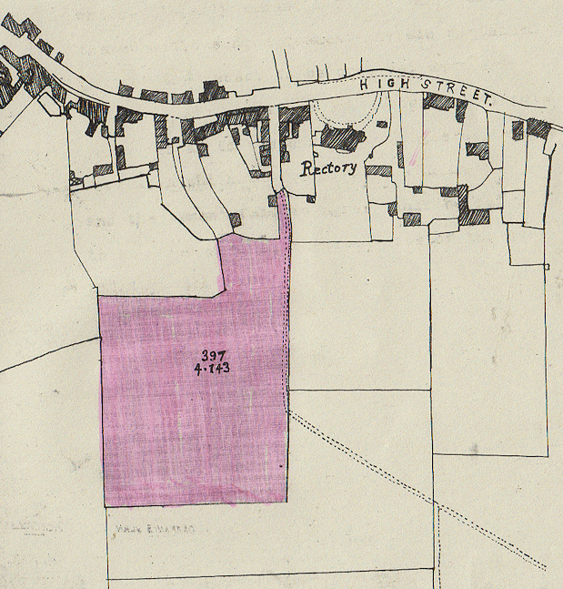
Research at the WSRO revealed that Angmering Parish Council (APC) took over the tenancy of the allotments from the Board of Agriculture and Fisheries on 16 Sept 1918. The land had been requisitioned from the Somerset family during WW1 for agricultural purposes, but it is not known whether the whole 4.143-acre site was cultivated for a single crop or whether villagers were allocated individual plots. So, there may have been allotments there a few years before 1918.
Notwithstanding that, the land was released back to the Somersets some time in 1918/19 and, on 29 September 1919, the Somerset's agent (Newland Tompkins) entered into a tenancy agreement with the Council for the tenancy of the Cottrells' allotments as they were then known, for a rent of £12 per annum. The Cottrells, incidentally, appear to have been named after a 14thC man by the name of Richard Coterel who owned or was a tenant of that land.
A map from the Agreements is shown below. This is interesting as it shows the limit of the Somersets' ownership of the lane itself. At that time, there was no fencing around the site on the east side, and the public footpath to the village ran along the edge.
In April 1933, alarm bells rang at the Parish Council when it was learned that the Somersets had received an offer for the allotments site, no doubt with a view to building on it. Councillor Edwin Harris - a socialist and great supporter of the working man - thought the Council should use every endeavour to purchase the site in order the allotments could remain. The Council agreed an offer of £550. However, nothing became of a sale and the ownership remain unchanged today.
It is interesting to note the names of some allotment holders in 1934 as they represent many old Angmering families. These included many well-known villagers' names including Green, Bennett, Edmunds, Heasman, Hammond, Burchfield, Wadey, Cheesman, Parsons, Holloway, Booker, Peskett, Reene, Bentley, Field, Rumsey, Pelham, Clear, Chalk, Horton, Penn, and more. The majority rented 10-rod plots from APC.
During WW2, the use of the Honey Lane site came into its own when the national 'Dig for Victory' campaign - launched in October 1939 - required the country to maximise its food production. However, after the war had ended, allotments fell steadily into decline.
But the 21stC saw a halt in this decline and a rise in the number of people wishing to rent allotments. It is thought that increased new housing, greater leisure time, and the desire to produce unadulterated 'green' food has greatly contributed to this surge of interest in allotment rental. A younger age group now also rent allotments which were once the preserve of mainly elderly men. The Honey Lane allotments appear to be no exception.
There have been numerous finds of the stems of old clay pipes dug up on the site. This is so far unexplained and there must be speculation that the site had been used for manual cultivation in some form long before the allotments were established, as the use of clay pipes had virtually died out by the end of the 19th century.
In 1990, the Honey Lane Allotments Association was formed to run the 130-plot site under the direction and on behalf of the Angmering Parish Council. In 2024, the yearly rental of a 'full' 5-rod plot was £30, and £18 for a half plot. Considering water is available on the site and it is fenced, the rents are not too dissimilar to allotments rents charged in 1897.
Honey Lane is so called because, at the beginning of the 20th century, one of the houses down the lane was renowned for its bee hives, and honey production.
Other Allotments Sites
There were a number of other small allotment sites in Angmering. These were probably unofficial and may not have lasted too many years. The known ones were all in the north-west part of the village. Current villagers recall the following sites:
- A small piece of land accessible by a footpath at the north-west corner of Lloyd-Goring Close.
- Land opposite the entrance to Bewley Road where The Heathers are located today.
- Land in Decoy Drive behind the gardens of 4-32 Palmer Road, facing the Sports & Social Club.
-------------- end ------------------
Neil A Rogers-Davis
09 March 2024
Acknowledgments:
I would like
to thank Jackie Barley, Ron Brown, Richard Cooper, Wendy Gregory, Ivan Smith,
and Maggie Somerset, for their contributions in assisting me to write this
article.
References:
Allotments and
Gardens website: www.allotments-gardens.org
West Sussex Record Office
documents: Par 6/49, Par 6/51/2, Par 6/52/1 & map, Par 6/54/1, Par 6/54/3.
"The Great Tithe of 1836", RW Standing, 2001
"Angmering Place Names",
by Nicholas Gould
Angmering (Honey Lane) Allotments Association
Page first uploaded 9 March 2024 (updated 23 March 2024)